 |
 |
| cover |
I wonder often whether it is worth continuing with this ancient form of blogging and never believe the tally of page views the blog has a month, the only way sometimes to know if anyone is out there (apart from the occasional comment). Something wonderful happened recently that will keep me going with this more "anti-social" media for a while longer.
I sent off a book-purchase to Robert Bolick in the UK and included several little books I thought he might like, to fill the box up a bit. Bob has this wonderful blog (also old technology) "Books on Books" which is so well done, superb photography, insightful text, and an incredible range of different artist's books.
Anyway, during our communications together, he made some valuable suggestions which I'm now following up on. This is the first little book in a series developed from my original little book, the form of which was inspired by Helen Malone's wonderful book and blog all those years ago. There you go, who would have thought the blogs could be so valuable.
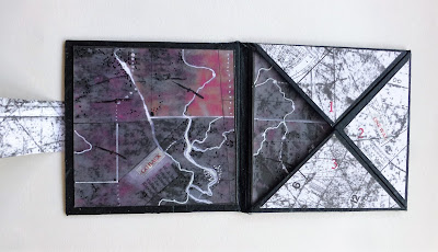
"Mapping #1" is the first of a series of books that deal with aspects of mapping in different worlds. This one contrasts the ancient rural outback of Queensland with the urban suburbs of old London Town. Different worlds at different times at opposite sides of the world on opposite sides of the book but able to be seen together at the same time.
The inside colour images refer to an aerial view of the landscape on the way to Kati Thanda-Lake Eyre, country of great significance to the indigenous people of Australia.
This imaginary image shows the shiny creeks and billabongs snaking through the dry desert. The aerial view gives it a different perspective, specks of white suggesting the swarms of pelicans and other birds while the raptors circle overhead.
The reverse side of the book, in contrast, refers to the growth and confusion of an old city on the other side of the world. A maze of busy lines, roads, boundaries, transport routes are used to connect collaged pieces of an old map of London in the Hackney area. Other texts and stamps suggest the intervention of man in this busy urban landscape.
PS. You may have noticed I have changed the name of the series from Mapping Tjukuru to Mapping. Tjukuru was a name I invented but it proved to be an actual word that did not fit.


5 comments:
Glad you've decided to stay here a while longer. Love the deceptive simplicity of this structure.
Thanks Jac. Always great to hear from the "stayers".
Another beautiful book Jack. You always manage to address the subject of land ownership and mapping so well. Love it!
I'm pleased you're going to keep blogging here. It's very enjoyable reading these posts. It's made me think I should get back to writing on my blog too - I've always got plenty to say!
Thanks, Helen. Yes, your blogs were always full of ideas and information.
Post a Comment